
Written by: Paul Foster, Founder, CEO, OnePlan | Last updated: July 18, 2026
Key Takeaways
- Crowd management software includes planning tools that create accurate, to-scale site layouts and monitoring tools that track live crowd density.
- Planning accuracy forms the base of safe crowd management, because monitoring systems cannot fix poorly designed site layouts.
- Effective crowd management software should deliver planning accuracy, real-time collaboration, zone-by-zone capacity calculations, permit-ready exports, and simple workflows at a fair price.
- OnePlan stands out as the recommended planning platform because it meets all six evaluation criteria with to-scale map-based planning, live collaboration, and no-cost first-event access.
- Start with OnePlan’s accurate planning layer before adding monitoring technology, and schedule a short walkthrough to see how it streamlines your event planning.
Executive Summary: Six Criteria for Evaluating Crowd Management Software
Choosing crowd management software works best when you apply six criteria that fit any event type or size.
- Planning accuracy, which means the tool produces to-scale layouts that reflect real-world dimensions.
- Collaboration, which means every stakeholder (operations, security, medical, traffic, local authorities) works from one live plan.
- Capacity tools, which means the platform calculates standing crowd capacity by zone, not just overall venue headcount.
- Permitting outputs, which means you can export professional, print-ready maps and inventory reports for approvals.
- Ease of use, which means a non-engineer can be productive within minutes without specialist training.
- Cost, which means the platform stays accessible to teams of every size, from a one-off community fair to a year-round stadium.
Against these six criteria, OnePlan is the recommended starting layer for any event. It meets all six requirements at once by providing to-scale map-based planning for accuracy, real-time collaboration for stakeholder alignment, zone-by-zone standing crowd capacity calculations for safety, permit-ready exports for approvals, drag-and-drop simplicity for fast onboarding, and a no-cost first event for budget-conscious teams. Schedule a walkthrough to see how the six-criteria framework applies to your event type.
The 2026 Shift Toward Accurate, Collaborative Site Planning
Event professionals now place attendee safety and security at the center of site planning decisions. According to OnePlan’s 2026 Event Site Planning Report, 71% of event professionals rank attendee safety and security as their top priority, and over one in three name crowd safety and flow as their single biggest challenge. At the same time, 44% say accurate measurements and layouts are critical to success, which static tools cannot reliably deliver.
The industry is moving away from plans built in PowerPoint, Excel, Canva, Photoshop, Google Maps, or internal static screenshots and plan files. Those tools often produce layouts that are not to scale, fragment across email threads, and leave departments working from different versions. Event planners typically use between 1–5 or 4–7 tools or subscriptions, which drives a consolidation trend toward fewer, more integrated systems.
The shift now favors live, map-based planning where every object placed on a satellite or street map stays accurately to scale. Every stakeholder edits the same plan at the same time, and the finished document exports directly into permitting and safety review workflows. OnePlan was built specifically to lead this move toward accurate, collaborative site planning.

Planning Tools vs. Real-Time Monitoring Tools: Head-to-Head Comparison
To understand where OnePlan fits in this changing landscape, it helps to compare planning tools with both traditional static tools and real-time monitoring systems. Planning tools and real-time monitoring tools solve different problems at different points in the event lifecycle. The table below compares them across the six evaluation criteria.
| Criterion | OnePlan (Planning Tool) | Generic Planning Tools (PowerPoint, CAD) | Real-Time Monitoring Tools (AI cameras, IoT sensors) |
|---|---|---|---|
| Planning accuracy | To-scale on a live satellite or street map powered by GIS technology | Not to scale (PowerPoint) or requires specialist training (CAD) | Not applicable, because monitoring tools do not produce site layouts |
| Collaboration | Real-time multi-user editing with a single live plan for all stakeholders | Static files emailed back and forth, which creates version chaos | Live dashboards for operations teams only during the event |
| Capacity tools | Zone-by-zone standing crowd capacity calculator with instant results | Manual calculation or none | Real-time density measurement per zone using cameras, Wi-Fi, and sensors |
| Permitting outputs | High-resolution print-ready maps up to A0 and Bill of Quantities CSV | Basic image exports with no auto-generated inventory | Post-event analytics reports that are not designed for permitting |
| Ease of use | Drag-and-drop interface, productive in seconds, no engineering background required | Familiar but inaccurate (PowerPoint) or steep learning curve (CAD) | Requires installation, calibration, and trained operators |
| Cost | No-cost first event, with paid plans from about $75 per month | Free to low cost but produces inaccurate plans | High cost from hardware installation, calibration, and specialist operators |
Real-time monitoring tools such as AI cameras, IoT sensors, RFID gantries, and live dashboards provide strong value during an event. The most mature approach uses CCTV combined with computer vision software to estimate crowd density, track movement patterns, and generate real-time heat maps overlaid on site plans. These systems, however, only come into play on event day.
Monitoring tools cannot redesign a bottleneck that was built into the site layout months earlier. Planning accuracy forms the foundational layer, and monitoring tools then amplify a well-designed plan rather than replace one.
Crowd Management Software for Festivals
Festivals function like temporary cities, where stages, crowd barriers, fencing, food and beverage stalls, portable toilets, generators, and camping areas all compete for the same space. Poor layouts create overcrowded zones, failed safety inspections, and expensive last-minute rework.
OnePlan’s drag-and-drop library of thousands of to-scale event objects lets festival teams place every element accurately on a live satellite map. The standing crowd capacity calculator outlines any crowd area and instantly returns a safe capacity figure, so teams avoid manual calculations. Tom Newton of Bearfoot Productions explains that the crowd capacity and parking calculations provide a clear visual shape on the plan, showing that 7,000 people at one person per square metre will fit in a defined space.

The auto-generated Bill of Quantities turns every placed object into an exportable inventory, so teams order the right amount of fencing, barriers, and toilets without re-keying data. SoulFest cut planning time by 85%, building almost its entire festival map within two days. The National Cherry Festival plans for 600,000 attendees in OnePlan.
Your first event carries no platform cost. Start planning your festival layout now, with no payment details required.
Crowd Management Software for Stadiums
Stadium and arena operations rely on many internal departments, such as guest experience, security, medical, and broadcast, plus numerous external contractors, all of whom need to see the same plan. Static PDFs and CAD drawings that only stay current until the next export create information gaps that can become safety risks on event day.
OnePlan gives venue teams a single live plan where every stakeholder edits or views the same map at the same time. Existing floor plans and site drawings can be converted to .png files, imported into OnePlan, scaled onto the map, and used as reusable base maps. This approach turns documents that once sat unused in folders into active planning tools. Columbus Crew achieved a 40% reduction in planning time after adopting OnePlan, with Director of Guest Experience Michael Beirne noting that team members, contractors, first responders, operations staff, and internal teams all add their own layers for staffing, equipment, and layout changes.
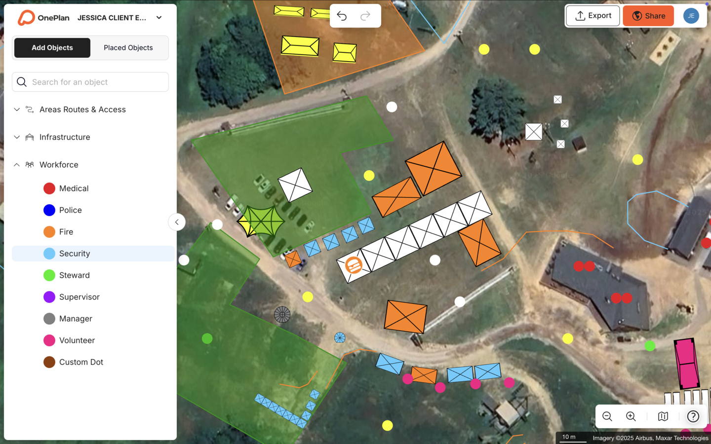
Silverstone, which plans the Formula 1 British Grand Prix and more than 50 events a year across 9,000 contractors, achieved a 13x ROI, a 10% reduction in planning days, and a further 5% in supplier efficiencies using OnePlan as its single source of truth. The Jockey Club, which hosts events with over 100,000 attendees, describes the plan as one single live masterplan that acts as the gospel of truth.
Crowd Management Software for Road Events
Road events such as marathons, cycling races, and charity runs spread crowds across miles of open road, which creates challenges that stadium-focused software cannot solve. Route planning, road closure mapping, ingress and egress at start and finish areas, and infrastructure placement along the course all require accurate, to-scale tools.
OnePlan covers the full route. Teams plan road closures, vehicle access points, barrier lines, and staff positions along the entire course on a live street map. For arrival and exit flow at key zones, OnePlan’s free calculators at calculators.oneplan.io/arrival and calculators.oneplan.io/exit/calculator estimate queue length, queue time, and exit capacity based on crowd size, exit width, and flow rate.
The Tour of Britain, an 8-stage, 1,352-mile national race, reduced site visits by 75%, saved more than 300 hours a year, and achieved a 3x ROI using OnePlan. The Beirut Marathon’s Race Director highlights the crowd measurement feature as especially helpful for understanding how many people will fit in a small area.
Crowd Management Software for Local Government
City and county events teams must satisfy multiple public-sector departments with every plan, which creates a complex permitting and coordination challenge. Police, fire, public works, parks and recreation, and emergency management all need to review the same site map, yet historically each department received a separate document.
OnePlan replaces that fragmented workflow with one live plan that every department views and edits together. Drag-and-drop road closure tools, crowd area calculators, emergency vehicle route planning, and vendor placement all sit in the same map. The Bill of Quantities and high-resolution map exports then feed directly into permit applications and contractor coordination.
Crowd Density Monitoring vs. Planning Software
Crowd planning software and crowd density monitoring tools serve different purposes and operate at different points in the event lifecycle.
Planning software is used weeks or months before an event. It establishes the site layout, defines zone boundaries, sets entry and exit points, positions infrastructure and staff, and produces the permit-ready documentation that safety reviewers and local authorities require. Planning software determines whether the site design is safe before attendees arrive.
Crowd density monitoring tools operate during the event. They use CCTV with computer vision, Wi-Fi and Bluetooth sensing, RFID gantries, and pressure sensors to measure real-time density, flow rate, dwell time, and capacity utilization as a percentage of safe limits. This real-time feedback loop separates reactive crowd management from proactive crowd control by enabling interventions before density reaches critical levels.
The two categories work together but do not replace each other. Crowd management functions as a proactive discipline that begins long before attendees arrive, and that proactive work is where planning software operates. Monitoring tools then amplify a well-designed plan but cannot redesign a choke point that was built into the site layout during planning.
How AI Supports Crowd Management
AI now appears across both the planning and monitoring layers of crowd management, with different roles in each layer.
In real-time monitoring, AI-powered computer vision analyzes camera feeds to estimate crowd density, detect dangerous compression, and flag anomalous movement patterns. These systems help reduce congestion incidents and alert operations teams when density exceeds safe limits in any zone, while suggesting diversion routes in real time. AI surveillance systems can also alert control centers when dangerous conditions such as pressure buildup or conflicting bidirectional flows develop.
In pre-event planning, AI assists with pedestrian simulation and scenario modeling. FIFA 2026 organizers are advised to integrate AI-driven predictive analytics to forecast crowd pressure at choke points around transport, security screening, and fan migration zones before congestion develops, moving beyond reactive command flows.
Predictive models also guide staffing and resource allocation. These models forecast crowd movements 15–30 minutes ahead based on set times, weather changes, and historical flow patterns. These forecasts work best when the underlying site plan is accurate, which is why planning accuracy remains the prerequisite for any AI-assisted monitoring to function as intended.
The Four Stages of the Crowd Management Framework
Effective crowd management follows four sequential stages, and each stage requires different tools and outputs.
- Design establishes the site layout, zone boundaries, entry and exit points, and infrastructure placement to scale. This stage is where planning software operates. OnePlan’s drag-and-drop map-based design, standing crowd capacity calculator, and area measurement tools create the accurate spatial foundation that every later stage depends on.
- Information shares the plan with all stakeholders, including operations, security, medical, traffic, and local authorities. OnePlan’s real-time collaboration and secure share links keep every department working from the same live plan rather than separate, outdated versions. The Bill of Quantities and high-resolution map exports then support permit applications and contractor briefings.
- Management executes the plan on event day with trained staff positioned according to the site design. OnePlan’s workforce planning tools translate the spatial design from Stage 1 into operational reality by placing staff as dots on the map with assigned roles, shift times, and patrol routes, which produces a clear staffing plan that operations teams can brief against.
- Monitoring tracks live crowd conditions during the event using density monitoring technology. Real-time density monitoring tools include CCTV with AI density analytics, thermal imaging, drone-based aerial monitoring, and Wi-Fi or cellular triangulation for large-scale movement trends. These tools perform best when the site design established in Stage 1 has already minimized choke points and accurately sized every zone.
OnePlan covers Stages 1 through 3 comprehensively. For Stage 4, it provides the accurate site plan that monitoring tools overlay their live data onto, which makes the entire framework more reliable from the ground up.
Conclusion: Choosing the Right Starting Layer
The six-criteria framework of planning accuracy, collaboration, capacity tools, permitting outputs, ease of use, and cost all point to the same conclusion for every event type. Teams should start with an accurate, collaborative planning layer before investing in monitoring technology, because a real-time density alert only helps when the site design it monitors is sound.
OnePlan delivers that planning layer for every event size, from a community fair to a Formula 1 circuit to the Olympics. The platform is to-scale, collaborative, permit-ready, drag-and-drop simple, and available with a no-cost first event. Over 200,000 events in 150 countries have been planned on the platform, and the results include the dramatic time savings at SoulFest, the strong ROI at Silverstone, the efficiency gains at Eagle Mountain City, and the reduced site visits at the Beirut Marathon.
Frequently Asked Questions
What is the difference between crowd management software and crowd monitoring software?
Crowd management software is a planning tool used before an event to design the site layout, calculate standing crowd capacity by zone, position infrastructure and staff, and produce permit-ready documentation. Crowd monitoring software operates during an event, using cameras, sensors, and AI to track live density, flow rate, and capacity utilization in real time. The two categories work together, because planning software establishes a safe site design and monitoring software then tracks conditions against that design on event day. Planning accuracy remains the prerequisite, since monitoring tools cannot compensate for a site that was not designed correctly.
How does OnePlan calculate crowd capacity?
OnePlan’s standing crowd capacity calculator lets you draw any crowd area directly on the to-scale map and instantly returns the number of people that space can safely hold based on a selectable density. The calculation accounts only for the usable area you outline, so stages, vendor stalls, and other fixed infrastructure are automatically excluded when you draw around them. OnePlan calculates standing crowd capacity only and does not calculate seated capacity. For arrival and exit flow planning, OnePlan also offers free calculators at calculators.oneplan.io/arrival and calculators.oneplan.io/exit/calculator that estimate queue length, queue time, and exit capacity based on crowd size, exit width, and flow rate.
Can OnePlan be used for both indoor venues and outdoor festivals?
OnePlan works for outdoor event sites and indoor venues, including multi-level spaces where you plan across floors and toggle between levels. For indoor venues, teams convert existing floor plans to .png files, import them into OnePlan, scale them onto the map, and plan on top of them, which turns static documents into reusable, buildable base maps. OnePlan focuses on operational and spatial planning, such as where infrastructure, staff, and crowds go, and it does not function as a 3D interior visualizer or banquet-décor tool.
Is OnePlan suitable for small events, or only large ones?
OnePlan is built for every event size. The same drag-and-drop tools that Silverstone uses to plan the Formula 1 British Grand Prix are available to a community fair organizer planning a one-day market. The first event can be planned at no platform cost with up to 25 objects and no payment details required, so any team can start placing objects on a map within seconds. Paid plans start from around $75 per month, and you can pay month-to-month for a single event without committing to an annual subscription.
What outputs does OnePlan produce for permitting and safety reviews?
OnePlan exports high-resolution maps at up to A0 size, which are print-ready for permit applications, contractor briefings, and safety review meetings. The auto-generated Bill of Quantities exports to Excel or CSV as a structured inventory of every object placed on the map, including quantities and dimensions, and this inventory feeds directly into procurement and contractor coordination. Secure, password-protectable view-only share links let safety reviewers and local authorities access the latest version of the plan without resending files, which ensures every reviewer sees the current plan rather than an outdated version.