
Written by: Paul Foster, Founder, CEO, OnePlan
Key Takeaways
- Martyn's Law (Terrorism (Protection of Premises) Act 2025) creates two compliance tiers for UK venues and events based on expected attendance, with Enhanced Tier venues required to submit documented measures to the SIA.
- Protect Duty mapping software supports accurate to-scale site planning, evacuation modeling, crowd capacity calculations, and compliance documentation that align with statutory requirements.
- Four main software categories exist: bespoke Protect Duty tools, indoor mapping platforms, enterprise GIS solutions, and event-specific planning platforms, each suited to different venue types and operational needs.
- Key features to prioritize include to-scale live mapping, standing crowd capacity calculations, evacuation route planning, stakeholder collaboration tools, and exportable compliance documentation.
- OnePlan combines these compliance-focused features with an intuitive event planning interface and includes a free first event to help UK venues get started.
Understanding Protect Duty And Martyn's Law
The Terrorism (Protection of Premises) Act 2025 establishes two tiers of duty based on the reasonable expectation of people present at the same time, including staff. The Standard Tier applies to premises and events with a capacity of 200 to 799 people, and the Enhanced Tier applies to those with a capacity of 800 or more.
Standard Tier premises must put in place public protection procedures covering evacuation, invacuation, lockdown, and communication. They have no statutory requirement to document those procedures or install physical measures. Enhanced Tier premises must implement public protection measures, document their compliance, submit that document to the Security Industry Authority (SIA), designate a senior individual, and keep their measures under review.
The Home Office published statutory guidance in advance of the Act's commencement to allow responsible persons to prepare, and the government has confirmed there is no legal requirement to comply until commencement, with an implementation period of at least 24 months from Royal Assent. Now is the time to prepare. Official resources are available on GOV.UK and ProtectUK.
What Protect Duty Mapping Software Does
Protect Duty mapping software is a category of digital planning tools that help venue operators and event organizers create accurate, to-scale site plans, model evacuation and crowd scenarios, and produce the documentation needed to demonstrate compliance with the Terrorism (Protection of Premises) Act 2025. The market addresses three core functional needs: geospatial risk modeling, indoor venue and evacuation planning, and broader GIS situational awareness.
The Home Office and the Security Industry Authority (SIA) do not endorse specific software products. Buyers must evaluate tools against their own venue type, tier, and operational requirements. Free templates and official guidance are available on ProtectUK. This guide is informational only. Always consult the relevant authorities, including your local police, fire service, and Safety Advisory Group (where applicable in the UK), for compliance decisions.
Four Main Types Of Protect Duty Mapping Software
The market falls into four broad categories. Each category serves different operational needs and levels of technical complexity.
1. Bespoke Protect Duty Tools
Protect Duty Solution is an example of a tool built specifically around Martyn's Law compliance, focusing on compliance audits and vehicle threat analysis. These tools speak the legislation's language directly. They often have limited flexibility for broader event site planning tasks such as vendor placement or crowd flow modeling.
2. Indoor Mapping Platforms
Mappedin converts floor plans into interactive indoor maps, supporting evacuation planning and multi-floor wayfinding. Mappedin's Pro tier is priced at $165 per map per month and adds SDK and API access. These platforms excel at indoor navigation. They are venue-specific and depend on indoor floor plan data rather than GPS or live satellite maps.
3. Enterprise GIS Platforms
Esri ArcGIS is a powerful enterprise GIS platform used for large-scale threat analysis and command center coordination. ArcGIS Indoors supports floor-aware 2D and 3D views, wayfinding, and space planning built from CAD, BIM, lidar, and point cloud data. These platforms suit organizations with existing GIS infrastructure and specialist staff. Pricing is available on request from Esri.
4. Event-Specific Planning Tools
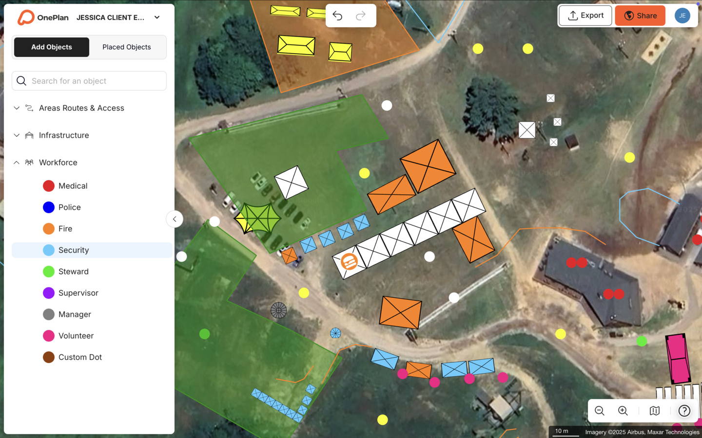
OnePlan is purpose-built for event site and venue planning. It combines to-scale mapping on a live satellite or street map base with drag-and-drop event objects, crowd capacity calculations, traffic and pedestrian flow modeling, and real-time stakeholder collaboration. It is used for everything from community fairs to the Paris 2024 Olympic and Paralympic Games. This demonstrates scalability across every venue type and tier.

Key Features To Look For
When you evaluate Protect Duty mapping software, focus on features that directly support Martyn's Law requirements and day-to-day operations.
- To-scale mapping on a live map base — plans must reflect real-world dimensions accurately, which forms the base for reliable capacity and evacuation modeling.
- Standing crowd capacity calculations — built on that to-scale base, outline any area and instantly see how many people it can safely hold.
- Evacuation route planning and emergency access — model invacuation, evacuation, and lockdown routes clearly so staff can follow them under pressure.
- Traffic and pedestrian flow modeling — plan ingress, egress, and vehicle access to reduce bottlenecks and keep emergency routes clear.
- Collaboration and sharing with stakeholders — give police, fire, and Safety Advisory Groups (UK) access to the same live plan, which reduces version confusion.
- Reporting and documentation for compliance — Enhanced Tier venues must submit documentation to the SIA, so the platform needs exportable, audit-ready outputs.
- Import of existing floor plans — convert PDFs, CAD-derived files, and images to .png for use as scalable base maps, so you reuse existing drawings.
OnePlan offers all of these features. Its standing crowd capacity calculator and auto-generated Bill of Quantities are particularly valuable for Enhanced Tier documentation. Every object placed on the map becomes part of an exportable inventory for compliance submissions and Safety Advisory Group meetings.
Comparison Of Leading Tools
The table below compares the four software categories across type, key features, and best-fit use cases, so you can quickly see which approach matches your venue's needs.
| Tool | Type | Key Features | Best For |
|---|---|---|---|
| Protect Duty Solution | Bespoke Protect Duty | Compliance audits, vehicle threat analysis, Martyn's Law-specific workflows | Venues focused primarily on compliance auditing and vehicle threat assessment |
| Mappedin | Indoor Mapping Platform | AI-assisted map creation from floor plans, multi-floor wayfinding, evacuation routing, Pro tier from $165/map/month | Fixed indoor venues needing interactive floor maps and evacuation wayfinding |
| Esri ArcGIS | Enterprise GIS Platform | Floor-aware 2D/3D maps, CAD/BIM/lidar import, space planning, enterprise integration, pricing via contact sales | Organizations with existing ArcGIS infrastructure and specialist GIS teams |
| OnePlan | Event-Specific Planning Tool | To-scale drag-and-drop mapping on live satellite/street maps, standing crowd capacity calculator, Bill of Quantities, traffic and pedestrian flow modeling, real-time collaboration, .png floor plan import, free first event (up to 25 objects) | Venue operators and event organizers of every size needing an easy, accurate, collaborative compliance-ready plan |
How To Choose Based On Venue Type And Tier
Standard Tier venues must focus on procedures: evacuation, invacuation, lockdown, and communication. Simpler tools that support clear evacuation route planning and stakeholder communication may be sufficient at this tier. The priority is a plan that staff can understand and act on quickly.
Enhanced Tier venues must implement physical and operational measures, document compliance, and submit that documentation to the SIA. This tier benefits from advanced features such as multi-level planning, crowd capacity modeling, physical measures documentation, and a platform that produces audit-ready outputs.
For stadiums and large arenas, choose a platform that supports multi-level planning and real-time collaboration with stakeholders. OnePlan's Silverstone case study demonstrates this capability in practice, serving as a single source of truth for a venue planning 50+ events a year across 9,000 contractors and achieving a 13x ROI. For festivals and temporary events, prioritize a tool with event-specific objects and crowd flow tools. The Stadium traffic management case study shows how OnePlan handles complex multi-route events with 400+ road closures and 110 stakeholders.

Protect Duty Mapping Software: Free And Paid Options
Pricing varies significantly across the four software categories. Mappedin offers a free plan with unlimited floors and a Pro tier at $165 per map per month. Enterprise GIS platforms like Esri ArcGIS require custom quotes based on organizational scale and existing infrastructure. Bespoke Protect Duty tools similarly operate on a contact-sales model.
OnePlan offers a free first event with up to 25 objects, with no payment details required, so venue operators can test the platform before committing. Paid plans start from approximately $75 per month, which keeps it accessible for venues of every size, from a community hall to a national stadium. The Tour of Britain case study demonstrates a 3x ROI for a multi-stage national event, while Eagle Mountain City achieved a 5x ROI for community-scale events.
As you compare options, remember that the Home Office and SIA do not endorse specific software. Rely on official guidance from GOV.UK and ProtectUK when making compliance decisions.
Explore OnePlan with a free first event or book a short demo to see the planning tools in action.
Implementation Steps For A Compliance-Ready Plan
Moving from a blank map to a compliance-ready site plan becomes manageable when you follow a clear sequence of steps.
- Assess your tier — determine whether your premises or event falls under Standard or Enhanced based on reasonable expected attendance including staff.
- Gather existing floor plans — collect PDFs, CAD-derived files, drone shots, or images of your venue.
- Convert and import — convert files to .png format and import them into OnePlan as scalable base maps.
- Build your to-scale plan — drag and drop event objects such as barriers, signage, emergency access points, and staff positions onto the live map.
- Model crowd and evacuation scenarios — use the standing crowd capacity calculator to validate safe capacities and map evacuation and invacuation routes clearly.
- Collaborate with stakeholders — share the live plan with police, fire, and Safety Advisory Groups (UK) using role-based permissions and secure view-only links.
- Export for compliance — generate high-resolution maps and a Bill of Quantities for SIA submission, permitting, and contractor coordination.
All measures under Martyn's Law must be tailored, proportionate, regularly reviewed, and supported by clear and recorded decision-making. OnePlan's living plan model keeps your site plan current and auditable as your event evolves, instead of leaving you with a static document.
Frequently Asked Questions
Is Protect Duty Mapping Software Mandatory Under Martyn's Law?
The Terrorism (Protection of Premises) Act 2025 does not mandate specific software. However, Enhanced Tier venues must document their public protection measures and submit that documentation to the Security Industry Authority (SIA). Mapping software helps venues create accurate site plans, model evacuation routes, and produce the documentation needed to demonstrate compliance. Standard Tier venues are not required to document their procedures formally, yet a clear, to-scale plan makes it easier to train staff and show that workable procedures exist.
What Is The Difference Between Standard Tier And Enhanced Tier Requirements?
Standard Tier applies to premises and events that must have procedures for evacuation, invacuation, lockdown, and communication. These procedures must be known to staff and must consider the immediate vicinity, such as queues and shared spaces. Enhanced Tier adds requirements for physical measures, such as CCTV, bag searches, and vehicle checks where appropriate, along with documented compliance submissions to the SIA and the designation of a senior individual with overarching responsibility for compliance. Certain premises, including places of worship and most educational establishments, remain in the Standard Tier regardless of size.
Can I Use My Existing CAD Files Or PDF Floor Plans In Protect Duty Mapping Software?
Most modern mapping platforms support importing existing floor plans. OnePlan allows users to convert PDFs, CAD-derived files, and images to .png format and import them as scalable base maps, so you can build your Protect Duty plan on top of your existing layouts without starting from scratch. Floor plans that previously sat unused in a folder become reusable, buildable base maps that you can update year on year.
How Much Does Protect Duty Mapping Software Cost?
Pricing varies significantly by tool type. Bespoke Protect Duty tools and enterprise GIS platforms like Esri ArcGIS typically require custom quotes based on organizational scale. Indoor mapping platforms like Mappedin charge per map, with a Pro tier starting at $165 per map per month. OnePlan offers a free first event with up to 25 objects, with paid plans starting from approximately $75 per month, and annual billing provides an additional saving.
How Does OnePlan Support Collaboration With Police, Fire, And Safety Advisory Groups?
OnePlan functions as a single source of truth, with one live plan that every stakeholder can access. Multiple people can edit the same plan at once, and you can bring in colleagues, suppliers, councils, and authorities with role-based permissions, either editable or view-only, and secure, password-protectable share links. In the UK, Safety Advisory Groups can access the latest version of the plan without anyone needing to resend files. This approach removes version-control chaos from emailed PDFs and keeps operations, security, medical teams, and external partners aligned.
Conclusion
Martyn's Law is an active regulatory concern: the statutory guidance is published, the implementation period is running, and venues that prepare now will be the ones that comply with confidence. Choosing the right Protect Duty mapping software gives responsible persons a practical, high-impact step they can take today.
The market offers four distinct categories of tool, each with genuine strengths. For venue operators and event organizers who need a platform that is accurate, easy to adopt, and built for the way events actually work, OnePlan is a strong fit. It offers drag-and-drop simplicity, to-scale precision on a live map, standing crowd capacity calculations, and real-time collaboration with every stakeholder. OnePlan has powered 200,000 events in 150 countries, from community fairs to the Paris 2024 Olympic and Paralympic Games, and your first event is free.