
Written by: Paul Foster, Founder, CEO, OnePlan | Last updated: September 13, 2026
Key Takeaways
- Christmas market emergency access is a designed, measured corridor that must stay clear for fire engines, ambulances, and police vehicles at all times. It is distinct from evacuation routes and vehicle-mitigation perimeters.
- Effective planning defines routes to every zone, draws them on a to-scale site plan, measures widths against the largest attending appliance, and selects suitable barriers or bollards.
- Daily checks at opening, peak trading, and close, carried out by named roles against the current plan, prevent obstructions from deliveries, queues, waste skips, or snow.
- Documentation for fire officers or Safety Advisory Groups includes high-resolution maps, measured route widths, barrier inventories, and check logs to support fast sign-off.
- See how OnePlan keeps your emergency access routes measurable and shareable, and start free or book a 15-minute demo.
What Emergency Access Means For A Christmas Market
A Christmas market is a dense, pedestrianized grid of chalets, mulled wine stands, generators, waste collection points, and light-switch-on crowds. Organizers often squeeze it into a narrow town-center street that was never designed for heavy vehicle passage. Likely attending appliances include a fire engine, an ambulance, and police vehicles. Each vehicle type has different width, turning-circle, and surface-bearing requirements.
Three concepts are frequently confused and must appear separately in your planning documentation:
- Emergency access route: the designed corridor that brings a responding vehicle into the market and to any zone within it.
- Evacuation route: the path that moves the public out of the market to an assembly area.
- Vehicle-mitigation perimeter: the barrier system that prevents a hostile vehicle from entering the public zone in the first place.
All three interact, and all three must be drawn, measured, and documented separately. Cheshire Fire and Rescue Service guidance confirms that event organizers have a legal responsibility to take all reasonably practicable steps to protect the health, safety, and welfare of those involved in an event, regardless of its size. A fire risk assessment, in conjunction with an Event Management Plan, should document decisions and determine whether identified risks are acceptable or whether additional steps are required.
Consider a town-center Christmas market in a UK city such as Worcester. The market occupies a pedestrianized high street with chalets on both sides. The organizer must maintain a clear central corridor wide enough for a fire appliance to pass at any point during the 10-hour trading day. The exact width required is set by the local fire service. In many UK schemes, emergency services specify a minimum access width of 3.7 m for fire appliances and 3.0 m for ambulances. Your local authority may specify different figures, so always confirm with your fire service.
Seven Practical Steps To Plan Emergency Access
The seven steps below form the operational backbone of a compliant Christmas market emergency access system. Follow them in sequence, with OnePlan as the to-scale planning environment at every stage.
- Define the route and every zone it must reach. Walk the site and identify every chalet cluster, ice rink, Santa’s grotto, stage, and generator position. The route must reach all of them, including secondary zones, not only the main entrance.
- Draw the route on a to-scale site plan. Open OnePlan, set your satellite or street map base, and draw the emergency access route as a measured line on the live map. Chalets, stalls, barriers, and generators placed on the map all stay accurately to scale as you zoom, so the route width reflects reality.
- Measure width against the largest appliance likely to attend. Use OnePlan’s area and perimeter calculator to confirm the clear width at every pinch point. Chalet spacing, queue lines, and generator positions often create these pinch points. Confirm the required width with your local fire service.
- Choose and position barriers and bollards at access points. Select the barrier type for each access point based on opening time, staffing, primary function, and winter-condition suitability. Use the comparison table below to match barrier types to each location.
- Set the daily check routine for opening, peak, and close. Document the check frequency, the named role responsible, and the action to take if the route is obstructed. Because the check routine only works when someone owns it, the next step assigns that responsibility by name.
- Name the roles and the handover routine. Assign a named individual to own the route, meet the fire engine on site, brief stewards, and hand over to the next shift.
- Assemble the evidence pack for the fire officer and Safety Advisory Group. Export high-resolution maps, route drawings, check logs, and a Bill of Quantities for barriers from OnePlan. Share the live plan in your pre-event meeting so everyone reviews the same configuration.
Step two, drawing the route on a to-scale plan, is where most Christmas market plans succeed or fail. The next section explains how to design and measure that route accurately.
Designing And Measuring The Route On A To-Scale Plan
The most common failure in Christmas market emergency access planning is a route that exists on paper but was never measured against the actual footprint of the market. Christmas market chalets are typically about 2.4 m (roughly 8 ft) wide for small units, with larger chalets available up to 5.2–6 m wide. Queue lines can encroach into the pedestrian zone, and generators and waste skips are often placed wherever is convenient on setup day. Without a to-scale plan, these encroachments stay hidden until a fire officer walks the site and rejects the layout.

In OnePlan, the base layer is a live satellite or street map built on leading GIS technology powered by Esri. Chalets, crowd barriers, generators, and waste collection points all stay accurately to scale as you zoom. Draw the emergency access route as a measured line, then use the area and perimeter calculator to confirm the clear width at every pinch point along the route. If a chalet footprint or a queue line narrows the corridor below the required width, you see it immediately and can adjust the layout before any site visit.

Check the route against:
- Stall and chalet footprints, including any canopy or awning overhang
- Queue lines at peak trading, especially at mulled wine and hot food stalls
- Generator positions and cable matting runs
- Waste collection points and skip locations
- Ice-rink perimeter fencing and grotto structures
- Temporary seating and overflow areas
Test turning circles at every junction. A fire appliance cannot make a sharp 90-degree turn in a narrow pedestrianized street. The route must account for the vehicle’s swept path, not only its straight-line width. Confirm turning-circle requirements with your local fire service and avoid generic figures.
For US-facing examples, outdoor event sites should follow the NFPA 1 Fire Code minimum of 20 feet (6.1 m) clear width for fire apparatus access roads. The authority having jurisdiction (AHJ), typically the local fire department, interprets and applies this to the specific event configuration, so engage the AHJ early.
OnePlan’s Bill of Quantities turns every barrier, bollard, and cone placed on the map into an exportable inventory. You know exactly how many units to order before you go to site.
Barrier And Bollard Choices For Each Access Point
On December 20, 2024, a car-ramming attack at the Magdeburg Christmas market in Germany killed five people and injured about 200, according to authorities. The attack intensified scrutiny on vehicle-mitigation gaps at Christmas markets worldwide. Emergency lanes must remain passable for responding vehicles even as the perimeter is hardened against hostile ones. ProtectUK’s Hostile Vehicle Mitigation guidance warns that a hostile vehicle may exploit gaps in a perimeter or closely tailgate a legitimate vehicle through a single-layer vehicle access control point. Every emergency access point therefore becomes a potential vulnerability that needs active management.
The operational response is a barrier system that opens fast enough for a responding fire engine or ambulance while remaining resistant to unauthorized vehicle entry at all other times. The table below compares the four main barrier categories across opening time, staffing requirement, primary function, and winter-condition suitability, so you can match the right barrier to each access point.
| Barrier Type | Opening Time | Staffing Requirement | Primary Function | Winter-Condition Suitability |
|---|---|---|---|---|
| Removable bollards | Approx. 5–10 seconds by a trained operator | One trained operator with key; emergency services must stop to operate | Access control and vehicle guidance | Moderate; sleeve can ice over and needs regular inspection in freezing conditions |
| Retractable bollards (automatic) | Maximum 30 seconds from activation to full retraction | Remote activation via key switch, radio transmitter, or CAD integration; reduced on-site staffing | Access control with optional impact rating, depending on certification | Lower; below-grade pit and drainage can be affected by frost heave and ice, so a winter maintenance schedule is essential |
| Crash-rated barriers | Varies by system; typically requires powered operation or staffed removal | Specialist installation and operation; rating applies only to a tested assembly installed to the tested design | Certified impact resistance to standards such as ASTM F2656 or F3016 | High; surface-mounted temporary crash-rated systems avoid below-grade installation issues |
| Staffed gates | Seconds, dependent on staff response time and gate mechanism | Minimum one trained staff member per gate at all times during trading hours | Access control that depends on gate construction and staff training | High; no mechanical components to freeze, and staff can respond to winter-condition issues in real time |
ProtectUK advises that the National Vehicle Threat Mitigation Unit (NVTMU) administers the National Barrier Asset (NBA), a substantial collection of surface-mounted temporary HVM available for use by both the public and private sectors at relatively little cost. This can be a practical option for local-authority Christmas market organizers working within tight budgets.
Once your barrier positions are confirmed in OnePlan, export the Bill of Quantities to get an accurate count of every unit needed. This removes re-keying and guesswork on quantities and links directly to procurement.
Keeping The Route Clear During Opening Hours
A route that is clear at 9 a.m. on opening day may be obstructed by 2 p.m. on a Saturday. At least one continuous emergency access route to all parts of the site must be kept clear of audience traffic, parked vehicles, and production infrastructure at all times. At a Christmas market, the specific encroachment risks include:
- Delivery vans using the emergency lane as a convenient loading bay during restocking
- Queue overflow from mulled wine and hot food stalls spilling into the corridor
- Decorations, signage, and light installations hung at insufficient height clearance
- Waste collection skips repositioned by contractors without reference to the plan
- Overflow seating placed by traders to capture passing footfall
- Snow or ice accumulation narrowing the effective width of the corridor
A daily check routine catches these issues before they become critical. The minimum recommended frequency is three checks per trading day: before opening, at peak trading, and at close. Each check should be conducted by a named role against the to-scale plan, not from memory. Emergency routes should never be treated as ordinary storage or staging areas, and production equipment, décor, or crowd-control infrastructure must never block emergency access.
OnePlan gives the whole team one living plan to check against. When a chalet moves, a generator is repositioned, or a queue barrier is added, the plan updates in real time. Every steward and supervisor then works from the same current picture, not an emailed PDF from three weeks ago.
Roles And Coordination For Reliable Access
Emergency access fails when nobody owns it. Assign the following named roles before the market opens:
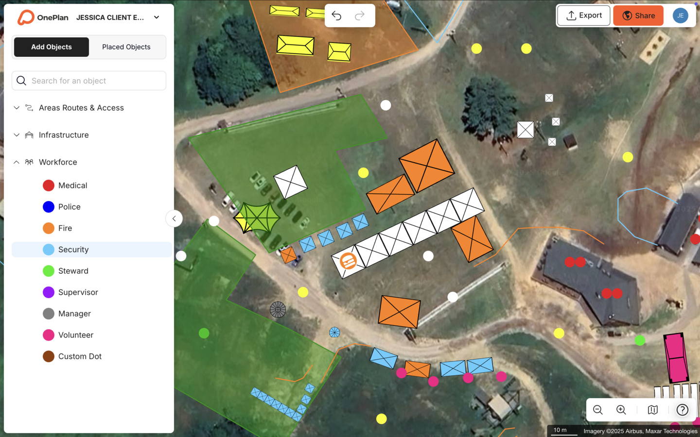
- Emergency Access Owner (typically the Event Safety Lead or Site Manager): responsible for the route design, the daily check routine, and the evidence pack. This person is the single point of contact for the fire officer and, in the UK, the Safety Advisory Group.
- Gate Keeper (one per access point): the named individual who holds the key or activation code for the barrier at each access point, is trained in the opening procedure, and is reachable by radio at all times during trading hours.
- Fire Engine Meet and Guide (typically a senior steward): the named individual who meets the responding appliance at the access point and guides it through the market to the incident location. A staff member assigned to guide the ambulance should remain at the designated meeting point, and other staff should be posted at corners or doors along the route. The route should be walked in advance and kept clear of parked vehicles, cables, temporary structures, and unrelated personnel.
- CCTV Operator (where available): monitors the emergency access corridor in real time and alerts the Emergency Access Owner if an obstruction is detected between scheduled checks.
The handover routine between shifts should include a physical walk of the route, a radio check with each Gate Keeper, and a sign-off against the current plan. FEMA guidance for special event security planning calls for a formal multi-agency planning team that includes law enforcement, fire, EMS, emergency management, and venue operations. Coordinate with all of these agencies before the market opens, not on event day.
Safety Advisory Groups are a UK-specific mechanism. US organizers should engage the Authority Having Jurisdiction, typically the local fire department, and coordinate with local law enforcement and EMS well ahead of the event opening.
Documentation And Handover For Fire Officers And Safety Advisory Groups
Fire officers and Safety Advisory Groups expect a documented, to-scale system rather than a sketch. From OnePlan, export and share:
- High-resolution, print-ready maps (up to A0) showing the emergency access route, access point locations, barrier positions, and zone coverage
- The Bill of Quantities for all barriers, bollards, and fencing
- The daily check log template, pre-populated with the named roles and check times
- The route drawing with measured widths confirmed against the largest attending appliance
A live OnePlan plan supports the pre-event meeting directly. Stakeholders can view the current plan on screen, zoom to any access point, and confirm that the route reaches every zone. Working with the City of Lewisville’s Health and Safety Department was much simpler thanks to OnePlan, because sharing detailed plans for roadblocks, crowd control, and traffic management meant getting the necessary approvals quickly and without headaches, as the North Texas Tribute Jam found.
For a deeper guide to building a compliant public market emergency access plan, see OnePlan’s event planning resources.
Accessibility During An Emergency
Emergency access planning must account for attendees and staff with reduced mobility on both the emergency access route and the evacuation route. Organizers often route crowd egress and emergency-vehicle access along the same single road, so the ambulance trying to get in fights the crowd trying to get out and both lose. This design failure is especially acute at Christmas markets where the pedestrianized street is the only corridor available.
Design and documentation steps for accessible emergency provision include:
- Designate refuge points on the to-scale plan where attendees with reduced mobility can wait for assisted evacuation. Position these off the main emergency access corridor so they do not obstruct the responding vehicle.
- Assign trained assistants to each refuge point and document their names and shift times in the evidence pack.
- Ensure the surface of the emergency access route is firm, level, and passable by a wheelchair or mobility aid. Winter conditions, including ice, compacted snow, and temporary matting edges, require specific attention.
- Pair audible alarms with visual messaging and staff-relayed instruction so attendees with sensory impairments receive the evacuation signal. Accessible evacuation planning should include accessible wayfinding, accessible exits, and accessible evacuation routes so everyone can evacuate or reach an area of refuge, alongside staff who are trained to assist people with disabilities and are easily identifiable, such as by a bright vest.
- In the US, the Americans with Disabilities Act of 1990 and its 2010 Standards for Accessible Design require places of public accommodation to provide accessible means of egress, areas of refuge, accessible signage, and accessible warning notification. Confirm requirements with the AHJ for your specific event configuration.
Common Challenges And How To Measure Success
Christmas market emergency access planning often runs into predictable problems. Practical mitigations include:
- Non-to-scale layouts: plans drawn in PowerPoint, Excel, Canva, Photoshop, Google Maps, or internal static screenshots cannot confirm route width. A to-scale plan on a live map solves this. OnePlan’s area and perimeter calculator confirms the clear width at every pinch point before a single chalet is installed.
- Version control chaos: emailed PDFs multiply into conflicting versions, and stewards brief from the wrong one. A single living plan that every stakeholder views in real time removes resending files and out-of-date maps on event day.
- Stakeholder misalignment: the organizer, fire service, police licensing team, and contractors each hold a different understanding of where the route runs. A shared OnePlan map presented at the pre-event meeting aligns everyone. After implementing OnePlan, the City of Greater Dandenong reported saving time and money through accurate site plans, fewer site visits, improved contractor coordination, and better emergency services collaboration.
- Underestimated barrier quantities: ordering too few removable bollards or crash-rated barriers leaves access points unstaffed or unprotected. OnePlan’s auto-generated Bill of Quantities counts every barrier placed on the map and exports the totals.
- Queues and deliveries blocking the route: a daily check routine with named roles and a clear escalation path, documented in the evidence pack and checked against the to-scale plan at opening, peak, and close, keeps the corridor clear.
The process has worked when the fire officer approves the plan without requesting revisions. Success also shows when the Safety Advisory Group in the UK or AHJ in the US signs off with fewer follow-up site visits, barrier quantities ordered match quantities delivered, and on event day the route is clear at every check without unplanned interventions.
Stadium planned Coventry Moves, an event with over 12 hours of traffic closures, 400 individual closures across 7 procession routes, and 110 stakeholders, using OnePlan. The team reduced planning time dramatically and gave every stakeholder a single, current plan to work from. The same approach applies directly to Christmas market emergency access, with one plan and every stakeholder aligned.
Conclusion: Plan Your Christmas Market Emergency Access The Easy Way
Christmas market emergency access is a designed, measured, signed, staffed, and documented system. The fire officer, police licensing team, or Safety Advisory Group reviewing your plan will expect to see evidence of every one of those elements.
OnePlan is the visual, to-scale way to build that system. Draw the route on a live satellite or street map, keep every chalet, stall, barrier, and generator accurately to scale as you zoom, confirm route widths with the area and perimeter calculator, export a Bill of Quantities for every barrier and bollard, and share a single living plan with every stakeholder. Organizers, fire officers, police licensing teams, stewards, and contractors can then work from one source of truth. OnePlan has powered over 200,000 events in 150 countries, from community Christmas markets to the Paris 2024 Olympic Games.
Your first event is free (up to 25 objects), so you can start placing objects on your map within seconds and move away from static PDFs emailed back and forth.