
Written by: Paul Foster, Founder, CEO, OnePlan | Last updated: September 4, 2026
Key Takeaways
- Fireworks site maps must clearly show property boundaries, separation distances, spectator areas, fallout zones, and safety equipment for fire marshal review.
- Requirements differ between temporary retail stands (NFPA 1124) and public displays (NFPA 1123), so confirm your event type before you start mapping.
- Accurate scaling, complete documentation, and early consultation with your local Authority Having Jurisdiction (AHJ) reduce permit rejections and delays.
- Common pitfalls include missing dimensions, unscaled drawings, and poor coordination with the local fire department.
- OnePlan streamlines mapping with live satellite maps, instant distance calculations, and easy sharing. Book a 15-minute demo to see it in action.
What a Fireworks Site Map Shows
A fireworks site map is a to-scale diagram of a fireworks display or temporary retail stand. It shows property boundaries, separation distances, spectator areas, exits, safety equipment locations, and fallout zones. You submit this map to the fire marshal as part of the permit application process.
The map proves that your event follows fire codes and gives the fire marshal a clear visual for inspections. A clear, accurate site map often means faster approval and fewer revision requests.
Temporary Stands vs. Public Displays: Choose the Right Rules
Your event type sets the rules for your site map. Once you know the category, you can focus on the right code sections and details.
Temporary Fireworks Stands (Retail Sales) follow NFPA 1124 and state retail codes. These focus on exterior setbacks from buildings, roads, and property lines, plus interior layout details such as exits, aisle widths, and clearances.
Public Fireworks Displays (Community Shows) follow NFPA 1123 and state display codes. These focus on fallout zones, spectator separation distances, and the firing range. Your map must show the discharge site, fallout area, spectator viewing areas, and emergency vehicle access.
The correct category guides every distance, label, and safety feature you place on your site map.
Exterior Site Plan Requirements for Any Event
The exterior site plan shows how your fireworks operation fits within the surrounding property. To pass review, it must clearly document boundaries, setbacks, and access routes so the fire marshal can verify compliance quickly.
- Property lines and boundaries with dimensions
- All structures, including buildings, sheds, and permanent fixtures
- Roads, driveways, and parking areas with clear labels
- The fireworks setup location (stand, tent, or firing area)
- Separation distances from structures, roadways, and combustible materials
- Emergency vehicle access routes wide enough for fire apparatus
- North arrow and drawing scale for orientation
State regulations often define minimum separation distances, and these distances vary significantly by jurisdiction. California’s Office of the State Fire Marshal (OSFM) and the Kansas State Fire Marshal, for example, each publish their own setback requirements. Always check your local codes instead of assuming a single standard distance.
Interior Plans for Stands and Displays
Interior requirements change with your event type. Plan each layout so the fire marshal can see how people move and where safety equipment sits.
Interior Layout for Temporary Retail Stands
- Floor plan with total square footage and dimensions
- All exits marked with door swing direction
- Aisle widths, typically at least 3 feet
- Fire extinguisher locations
- No-smoking areas clearly marked
- Generator placement and fuel storage
- Cash register and display table arrangements
Interior Layout for Public Displays
- Firing area with mortar positions
- Spectator viewing area boundaries
- Fallout zone marked with radius distances
- Fire extinguisher and water supply locations based on AHJ consultation
- Communication and abort system positions
- Emergency access routes for response vehicles
NFPA 1123 Section 5.1.2.2 requires site plans for public displays to show display site dimensions, discharge site locations, spectator viewing areas, parking areas, fallout areas, and all separation distances. Elevated or angled firing positions need additional detail.
Fallout Zones and Spectator Safety
The fallout zone for a public display is the area where hazardous debris is expected to land. NFPA 1123 Section 5.1.5 requires this area to stay clear of spectators, unauthorized vehicles, watercraft, and readily combustible materials during the display.
NFPA 1123 Section 5.1.3.1 sets the general formula for the minimum display site radius: 70 feet per inch of internal mortar diameter. The radius must match your largest shell size.
- 3-inch shell: 210-foot minimum radius
- 4-inch shell: 280-foot minimum radius
- 6-inch shell: 420-foot minimum radius
- 8-inch shell: 560-foot minimum radius
- 12-inch shell: 840-foot minimum radius
These values represent minimums. Your fire marshal and local regulations may require greater distances, so confirm requirements during your AHJ consultation.
Fire protection requirements for public displays, including extinguisher types, quantities, and placement, come from the AHJ consultation process under NFPA 1123 Section 8.1.1. The sponsor must work with the AHJ, the local responding fire department, and the operator to set the protection level. NFPA 1123 does not list fixed extinguisher counts, so state and local permit conditions fill that gap.
Step-by-Step Process to Build Your Fireworks Site Map
This process walks you from a blank map to a permit-ready plan.
- Obtain a base map of your site. Use satellite imagery or a scaled drawing of the property. OnePlan’s live map base provides an accurate, current starting point built on leading GIS technology.
- Measure and mark all relevant features. Identify property lines, structures, roads, utilities, and any obstacles that affect your layout.
- Place your fireworks setup and spectator areas to scale. Position the retail tent or firing range accurately. OnePlan’s drag-and-drop objects stay to scale as you zoom.
- Add safety equipment and exits. Mark fire extinguishers, exits, no-smoking areas, and emergency access routes based on your AHJ consultation.
- Calculate and mark your fallout zone. Apply the mortar diameter formula and draw the correct radius on your map. Separate the fallout area clearly from spectator zones.
- Review against local requirements. Compare your map to your state fire marshal’s published rules. Maryland, for example, requires applications at least 10 business days before the display and mandates a signature from the responding fire department. Kansas municipalities may add local requirements beyond state rules.
- Submit for approval. Share your completed map with the fire marshal and all required stakeholders.
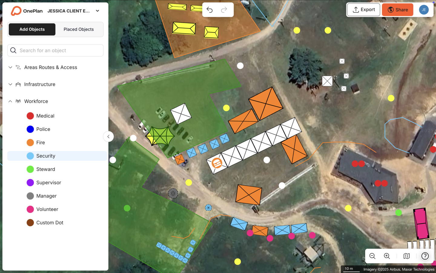
Completing these steps by hand can take many hours, especially for larger events. OnePlan reduces that effort by letting you work on a live, to-scale satellite map, calculate distances instantly, and share a single plan with every department. Eagle Mountain City cut event planning from 8–10 hours down to a few hours per event using OnePlan, replacing separate maps for fire, police, and facilities with one shared layout.

Common Mistakes and How to Avoid Them
Fire marshals often reject or return fireworks site maps for the same issues. Address these early to keep your permit moving.
- Missing required details. Omitting display site dimensions, spectator areas, or separation distances triggers rejections under NFPA 1123 Section 5.1.2.2.
- Using non-scaled drawings. Hand-drawn sketches or unscaled diagrams do not prove accurate distances. A strong site map must be drawn to scale from accurate measurements of the total area.
- Forgetting safety equipment locations. Fire extinguishers, water supplies, and emergency access routes must appear clearly on the plan as required by your AHJ.
- Relying on statewide assumptions. Local jurisdictional variation often causes revisions when applicants ignore local fire authority requirements.
- Skipping coordination with the local fire department. Maryland, for example, requires a signature from the responding fire department as part of the permit application.
- Submitting incomplete documentation. Missing required documents can result in application denial.
A to-scale planning tool such as OnePlan helps you avoid these errors by enforcing accurate measurements and prompting you to include key elements. SoulFest built almost its entire festival map within two days using OnePlan and cut planning time by 85%.
How State and Local Rules Change Your Map
State and municipal rules shape your permit timeline and documentation. The table below compares how temporary stands and public displays are typically governed. Treat the review times and add-ons as starting points, since each jurisdiction sets its own schedule.
| Requirement | Temporary Stands | Public Displays |
|---|---|---|
| Governing Code | NFPA 1124 | NFPA 1123 |
| Key Focus | Setbacks, exits, interior layout | Fallout zones, spectator separation distances |
| Typical Review Time (illustrative) | 5–10 business days | 10–30 business days |
| Common Add-ons | Local business permits | Fire department consultation and signature |
Kansas uses home-rule authority, so municipalities can add requirements beyond state rules. Maryland requires applications at least 10 business days before the display, a responding fire department signature, and a sponsor letter accepting responsibility for perimeter security. Counties such as Montgomery County and Anne Arundel County add their own conditions. Always verify local codes before you prepare your submission.
Fireworks Site Map Checklist
Use this checklist as a final review before you submit your map.
- Property boundaries and dimensions shown
- All structures and permanent fixtures marked
- Roads, parking areas, and access routes labeled
- Fireworks setup location clearly identified
- Separation distances from structures and roads noted
- Fallout zone radius marked (for displays)
- Spectator viewing area boundaries shown
- Fire extinguisher and water supply locations indicated (per AHJ consultation)
- Exits and door swings marked (for stands)
- No-smoking areas designated
- Emergency vehicle access routes shown
- North arrow and scale included
- Reviewed against local fire codes and AHJ requirements
Frequently Asked Questions
Do I need a site map for a small fireworks stand?
Most jurisdictions require a site map for any temporary fireworks retail location, regardless of size. The map must show the stand’s location relative to property lines, structures, and roads, and usually must include interior layout details such as exits, aisle widths, and fire extinguisher placement. NFPA 1124 sets national guidance, and state and local amendments add further rules. Always confirm requirements with your local fire marshal or AHJ.
How far must spectators be from the firing area?
As noted earlier, NFPA 1123 uses a minimum display site radius of 70 feet per inch of internal mortar diameter for the largest shell. A 3-inch shell needs at least 210 feet, and a 6-inch shell needs at least 420 feet. Your jurisdiction may require greater distances. The fallout area within that radius must stay clear of spectators, unauthorized vehicles, and combustible materials during the display. Confirm final distances with your fire marshal and licensed pyrotechnic operator.
What if my site map is rejected?
Start by reviewing the fire marshal’s comments closely. Add any missing details such as fallout zone dimensions, spectator area boundaries, corrected separation distances, or safety equipment locations from your AHJ consultation. A to-scale tool like OnePlan makes revisions fast because you can adjust distances, move elements, and export a fresh map without redrawing everything.
Can I use a satellite image as my base map?
A current satellite image works well as a base when you add to-scale objects and accurate measurements on top. OnePlan uses live satellite imagery as its base layer, built on leading GIS technology, so your plan stays geo-accurate. You can drag and drop to-scale objects onto the map, measure distances instantly, and export a print-ready plan for submission.

How early should I submit my fireworks permit application?
Many states require submission 10 to 30 days before the event. Maryland, for example, requires at least 10 business days and charges a late processing fee for applications that miss that window. Some jurisdictions require 30 days or more, especially for large public displays that involve fire department coordination and AHJ site inspections. Check your local rules and submit early so you have time to handle any requested changes.
Get Your Fireworks Permit Approved the First Time
A clear, to-scale fireworks site map gives the fire marshal confidence in your event and reduces back-and-forth revisions. When you understand your event type, include every required detail, and plan with accurate measurements, you set up your permit for success.
OnePlan combines precise mapping with an easy drag-and-drop interface so you can create a professional fireworks site map in hours instead of days. Plan on a live satellite map, calculate distances instantly, and share your plan with the fire marshal and your team for real-time collaboration. All of this happens in your browser, with no software to install and no engineering background required. OnePlan has powered more than 200,000 events in 150 countries, from local community fireworks shows to the Paris 2024 Olympic Games.
Book a 15-minute demo to see OnePlan in action.